Monday, July 21, 2008

Westwater Ruin & Edge of the Cedars

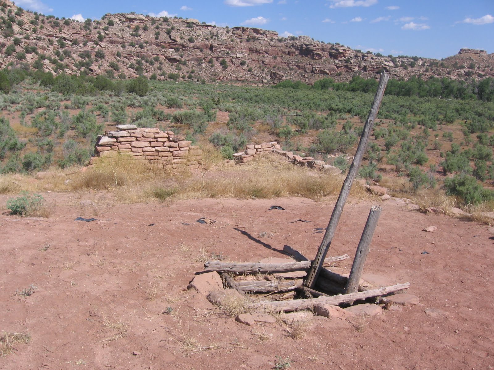
The Westwater Ruin is an Ancestral Pueblo canyon rock alcove site just south of Blanding in southeast Utah. It is located about 2 miles west along road 1200 South, which isn't marked.


The Westwater Ruin is an overlook site. I didn't see an easy trail across the canyon, though it looked like the agile could probably get over there.


Westwater Ruins is thought to have at least 13 ground level rooms and 5 kivas. There were also probably some upper level rooms. The site may have been occupied as early as 750 AD and abandoned by 1300.
This canyon has other ruins nearby, including the pueblo at the Edge of the Cedars Museum.
 
Down the canyon is to the south and the canyon appears to get deeper. There is some riparian habitat at the bottom of the canyon indicating permanent water. Up the canyon to the north the Blue Mountains are visible. This site has a good road going out to it, but there is no interpretive information and it doesn't appear to be protected except by its difficult location.
 

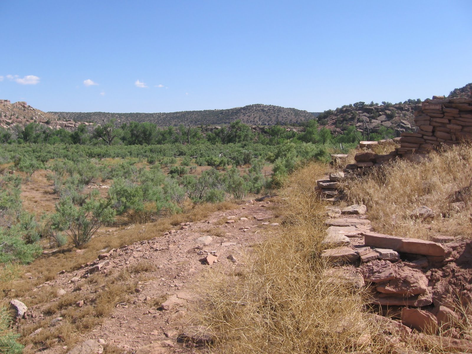
Edge of the Cedars is a Utah State Park in central Blanding. There is a partially excavated Ancestral Pueblo site there with a small museum. This is a site that appears to have had three lives. The first occupation lasted from 825 to 950 and the second from 1050 to 1125. In the early 1200s there was some remodeling with the site thought to be vacant during the intervals in between.

Then as now there were advantages to this location including the fine views of the nearby Abajo Mountains. The Edge refers to the biological boundary between the sagebrush fields and the Pinon Pine and Juniper forests. The trail here is short and visitors have to pass though the museum to get to the ruins site.

There is a reconstructed kiva than can be entered. The excavated sections of the site show part of the Great House. About 17 rooms and two kivas are visible. There is an unexcavated Great Kiva on the south side, appearing as a circular depression.

The abutment joints of walls show that the site was remodeled over a period of time. The stones used in building the site are a mix of flat tabular sandstone that had to be carried a long distance and more local chunky rocks. In the chunky layers, small chinking stones were used.

The Museum has a large collection of ancient pottery. At many of the ancient sites looting by collectors occurred before the sites were protected, so it's rare to see a lot of preserved ones on display.


Edge of the Cedars is a good place to find red ware pots, found mostly in southeast Utah and northeast Arizona.  It is common to find pottery shards in the region and it is odd to think that the shards have been laying there for 700 years.

There is also a sculpture near the ruins site that replicates some of the archaeoastronomy sites in the southwest. In some locations, spears of light hit spirals or other symbols on the significant days of the solar year.


Sunday, July 20, 2008

Westwater Canyon Trail


The Westwater Canyon Trail is located on the south side of Blanding, Utah at road 500 South only about one block west of the main road Highway 191. This isn't the same site as the Westwater Ruin, which is about two miles to the southwest, further down the same canyon.

There are trails along the rim of this desert canyon going to the north and south. The south trail has some displays of the historical heritage of the area. There is good desert hiking to the north much of it on an ATV trail.
In the Heritage Trail section to the south there is an observation tower and an amphitheater. From the tower there are good views of the canyon area and the Blue Mountains to the north. This is a desert canyon with Pinon Pine and Utah Juniper trees and sage brush dominating.

The cultures represented include the Navajo Indians whose large Reservation is not far to the south. Two reconstructions of the traditional Hogan dwellings of the Navajo are presented along with an oven and a shade house structure.

The Anglo reconstruction shows and cabin and a variety of old farm implements. There were several historic old wagons and wheels on display also. These different sites are connected by a network of trails rather than a loop.

The Spanish Village has a small building and a corral and out building. The hiking trail to the north descends into the canyon and crosses and seems to go a long ways on the west rim. There are some minor Ancestral Pueblo sites just under the canyon rims.
I hiked around this area for about 1:20 on a hot mid summer day.


Friday, July 18, 2008

Indian Creek Trail-Blue Mountains

The Indian Creek Trail is on north side of the Blue or Abajo Mountains west of Monticello in southeast Utah. This is the same Indian Creek that flows past Newspaper Rock on the way to the Needles District of Canyonlands National Park.

The trail head is marked 021 and is located about two miles past Foy Lake down a narrow steep dirt road. The road to the trail head would make a good hike in itself with good views down the deep Indian Creek Canyon.
 
 The first part of the trail descends steeply down toward the Indian Creek and then the trail descends gently, passing through mostly lush riparian habitat. The Indian Creek was still flowing well in midsummer. The Pinon Pine and Utah Juniper at the trail head changed quickly to narrow-leaf cottonwoods and willows, with some box elder and birch.

In some places there were stands of Ponderosa Pines and a few Douglas Firs. In the moist areas Rocky Mountain Red Cedar replaced the Utah Juniper. Some of the Ponderosas were the old yellow barks that aren't seen very often. The sandstone cliffs that were visible from the trail are only the inner canyon. Views from higher up show this to be a very deep canyon.
 
 This appeared to be a little used trail. There were no footprints from other hikers here in midsummer. The only other users appeared to be cattle. I walked down the trail for 1:30 and came back up in about the same for a total hike of 3:00 hours.

Friday, July 11, 2008

Robertson Pasture Trail-Blue Mountains

The Robertson Pasture Trail is in the Blue or Abajo Mountains west of Monticello in southeast Utah. This small mountain range is one of several in the region that was formed as an igneous intrusion, molten rock pushing up and folding the overlying rock but not forming a volcano.


I started my hike at Foy Lake which is about 11 miles straight west of Monticello. There are several other trail heads in the vicinity of this small lake.

The trail starts in rich Pinon Pine and Juniper forest with  Gambel Oak mixed in. The route circles counter clock wise around North Peak at 10, 823 feet, and climbs fairly steeply.

Wildflowers are good along this trail. The lower part of the trail has good views to the north toward the Canyonlands National Park area. An area of petrified sand dunes is visible.

As the trail swings around the south side of North Peak the views to the west open up. The area to the west is the Dark Canyon Wilderness and Primitive Areas.

Arriving at the open meadow pasture areas there are views of Abajo Peak, at 11,014 feet the tallest point in this range. The Robertson Pasture Trail continues on and connects with other trails. I stopped after 2:15 hours at the point that seemed to be the crest of the Pasture area and returned to Foy Lake, going down in 1:15 hours, for a total hike of 3:30 hours.


Thursday, July 10, 2008

Three Kiva Pueblo in Montezuma Canyon

Three Kiva Pueblo is a remote Ancestral Pueblo site along the rugged Montezuma Creek Road between Monticello and Blanding in southeast Utah.


The challenge of this site is finding it. Montezuma Creek Road, C-146, is five miles south of the Visitor Info Center in Monticello, Utah off of Route 191, but is not marked. The road is gravel to start out and descends steeply into Montezuma Canyon.

The canyon floor at the north end is mostly privately owned and there are some irrigated hay operations and a few private homes. It is 27 miles along this road to Three Kiva while the road gradually becomes narrower, loses the gravel and is rougher.


The site is small and isolated. There are many other Ancestral Pueblo sites in Montezuma Canyon but they are on private land and not accessible. Some of these sites are visible from the road, particularly in the three miles north of the Three Kiva site. This site is thought to have 14 rooms, three kivas, and a few other features including a possible turkey run.


The highlight of this site is that one of the kivas has been reconstructed and visitors can climb down the ladder through the roof and sit inside the subterranean ceremonial structure. This was welcome on a 95  F. degree day as it was cool and shady below. (In June 2011 I noticed that the ladder is missing.)


The low ceiling made the bench useless. I suppose there is some height missing here. All the features of the Kiva were otherwise in place. Another reconstructed Kiva in the region is the Great Kiva at Aztec Ruins in northwest New Mexico. Other reconstructed kivas that can be entered are at Edge of the Cedars in Blanding, Utah and Spruce Tree House at Mesa Verde National Park.


The other feature that I wonder about is that the roof entrance is also the chimney for letting smoke from the fire escape. Hold your breath when entering and make sure no one stokes the fire just as you descend over it.


The environmental setting here is mostly dry Sagebrush on the canyon floor with Pinon Pine and Juniper on the canyon sides. The creek supports a lush growth of Cottonwood Trees so it must be a good source of water. The canyon floor is wide enough for extensive farming.

Continuing south on the rugged road, it is seven miles until a better gravel road is reached, then nine miles to the paved roads at the Hatch Trading Post area. Keep an eye out for rock art on the west side cliffs a few miles south of Three Kiva. If traveling to Three Kiva Pueblo from the south, the right turn onto C-146 is easy to miss.


18407_$5 Shipping on Orders of $99 or More!