Sunday, June 12, 2011

Three Kiva Pueblo Neighbors

The Three Kiva Pueblo is an accessible Ancestral Pueblo ruins site in the Montezuma Canyon in southeast Utah. Much of the floor of Montezuma Canyon is private property but there are several small ruins sites that can be viewed from the road.

 Three Kiva Pueblo is about 27.7 miles south from the north end of Montezuma Canyon Road. High on the cliffs to the east of Three Kiva a small storage structure is visible with binoculars under an overhanging rock. (It is in this picture but is hard to see.)

 A small granary site is about 0.8 miles north. There is a side road leading to the area below the structure.


The largest site that I saw was 2.9 miles north. There are several cliff structures in a wide alcove with some rubble structures below. 

This site has a protective fence in front. This site also has a loop side road leading to the site.
 

The northern area of the Montezuma Canyon has many alcoves. Most are hard to see from the road but there is one where some wall fragments are clear. This site is about 13.4 miles north of the Three Kiva site. Traveling slowly along the 35 miles of Montezuma Canyon and stopping when I though I saw something took about 3 hours. There are more sites than I mention here and probably more that I missed.


Thursday, June 9, 2011

Montezuma Canyon Rock Art

Three Kiva Pueblo is a publicized Ancestral Pueblo site along the rugged Montezuma Creek Road between Monticello and Blanding in southeast Utah. The north end of Montezuma Creek Road, C-146, is five miles south of the Visitor Info Center in Monticello, Utah east off of Route 191.


About 6.8 miles south of the Three Kiva Pueblo, there are cliffs close to the road with several petroglyph panels. There isn’t a sign but there is a turnoff parking spot on the west side of the road. The panels extend for several hundred feet.
 
It is a short climb up to the base of the cliffs and there is a primitive trail to follow. Some of the figures must be relatively recent and include riders on horses.


The figure in the upper left seems unusual. The bottom part resembles a flute player, but the part on top is more elaborate than the usual flute player head dress.
 
Some of the figures appear much older and ghostly in appearance. To the right, it looks like the larger figure is standing on the shoulders of the smaller figures.


The bird images are particularly clear. They look like herons or some shorebird. There is water in the Montezuma Canyon but I didn’t see any wetlands that would provide habitat for this type of bird.


Wednesday, June 8, 2011

Wagon Wheel Trail-Blue Mountains

The Wagon Wheel Trail visits the east side of the Blue Mountains in the Manti-La Sal National Forest in southeast Utah. The trail head is 5.4 miles along the forest road past the Devils Canyon campground. The campground is between Monticello and Blanding, Utah on the west side of Highway 191.

At the trail head area there is a primitive campground area with a restroom. The trail head for the Camp Jackson Trail is 0.4 miles further along the forest road. In this area, there is a network of ATV trails and many of the side forest roads have trail markers.

Besides being numbered as trail 168, the Wagon Wheel Trail appears to have an ATV Route 90 designation. The trail head elevation is about 8200 feet and the trail climbs about 800 feet in 2 miles.
 
The route passes through Ponderosa Pines and Gambel Oaks with Aspens appearing as the trail climbs. There are views of South Peak at 11, 419 feet, and a cliff layer that the peak rests on. After about 0:25 minutes of hiking there is a trail junction. The main route is marked to the right, continuing north. I detoured to the left and followed the side trail climbing another 0:20 minutes until it dead ended at a canyon rim.
 
I thought the side trail was more scenic than the main trail with views to the west toward the Bears Ears and the canyon country of Cedar Mesa. There were also good views back to the east toward Sleeping Ute Mountain and the LaPlata Mountains. The Camp Jackson Trail may descend down into this canyon area.
 
Back on the main trail, there are views of South Peak all along the way. In early June, there were several moist meadows along the way with Iris in bloom.
 
The route continues north, and crosses Verdure Creek and North Fork Creek, each with a small bridge. The first creek had many maple trees in the moist drainage. There is another trail junction between the creeks and I stayed to the right following the marker for ATV Route 90.

I turned around about 0:15 minutes past the trail junction, about 2.5 miles from the trail head. My return hike took 1:00 hour. My total hike including the side trail took 3:30 hours for about 7 miles. I carried and drank 2 liters of water on a 62 F degree early June day.
 
 At the Devils Canyon Campground, there is a short 0.2 mile interpretive trail that is themed “The Forest and Man.” There is a trail guide and 12 stops that discuss the forest trees and signs of forest fires and forest use by man.

At stop 12 a small Ancestral Pueblo storage ruin is visible across Devils Canyon. Devils Canyon runs 13 miles southeast and joins Montezuma Canyon where there are also many ruins sites.


528614_Russell Outdoor Logo 125x125

Sunday, June 5, 2011

The Telluride Blanket

In 1896, ranchers Mel and Ed Turner were searching for stray cattle somewhere in the canyons of southeast Utah and found a perfectly preserved high quality woven blanket. This blanket, some yarn, and a picture of an alcove ruin later came into the possession of Telluride banker W.E. Wheeler.

The Wheeler estate passed to the Pekkarine family who in 1970 left their possessions to the Telluride Historical Museum. After nearly a century of resting in Telluride, the significance of the blanket was realized. In 1994, the picture of the alcove was published with an appeal for help in locating the site where it had been found.

Only three other pre-historic perfectly preserved blankets are known. The Telluride Blanket is the only brown, red, and white twill fabric from the time period of 1041 to 1272 AD.

The Telluride Historical Museum is located in the restored 1896 Hall’s Hospital at 201 West Gregory Ave. This location is very close to Tomboy Road and the east trailhead for the Jud Wiebe Trail. I visited the museum after hiking the Jud Wiebe Trail clockwise, starting at the Cornet Falls west side trailhead.
 
The museum interpretive display says that a researcher led a visit to the site where the inscriptions of “E. Turner” and “Mel Turner” and “1896” were found. The recent guide to interpreting archaeology sites, “The Cliff Dwellings Speak” by Beth and Bill Sagstetter has an account of the story and site visit in Chapter 14.

The author describes how the documentation of early explorations is often separated from the artifacts recovered and an effort called Reverse Archaeology is needed to fill in the information gaps. The efforts by Fred Blackburn and the rediscovery of the Wetherill Cave 7 are an example.
 
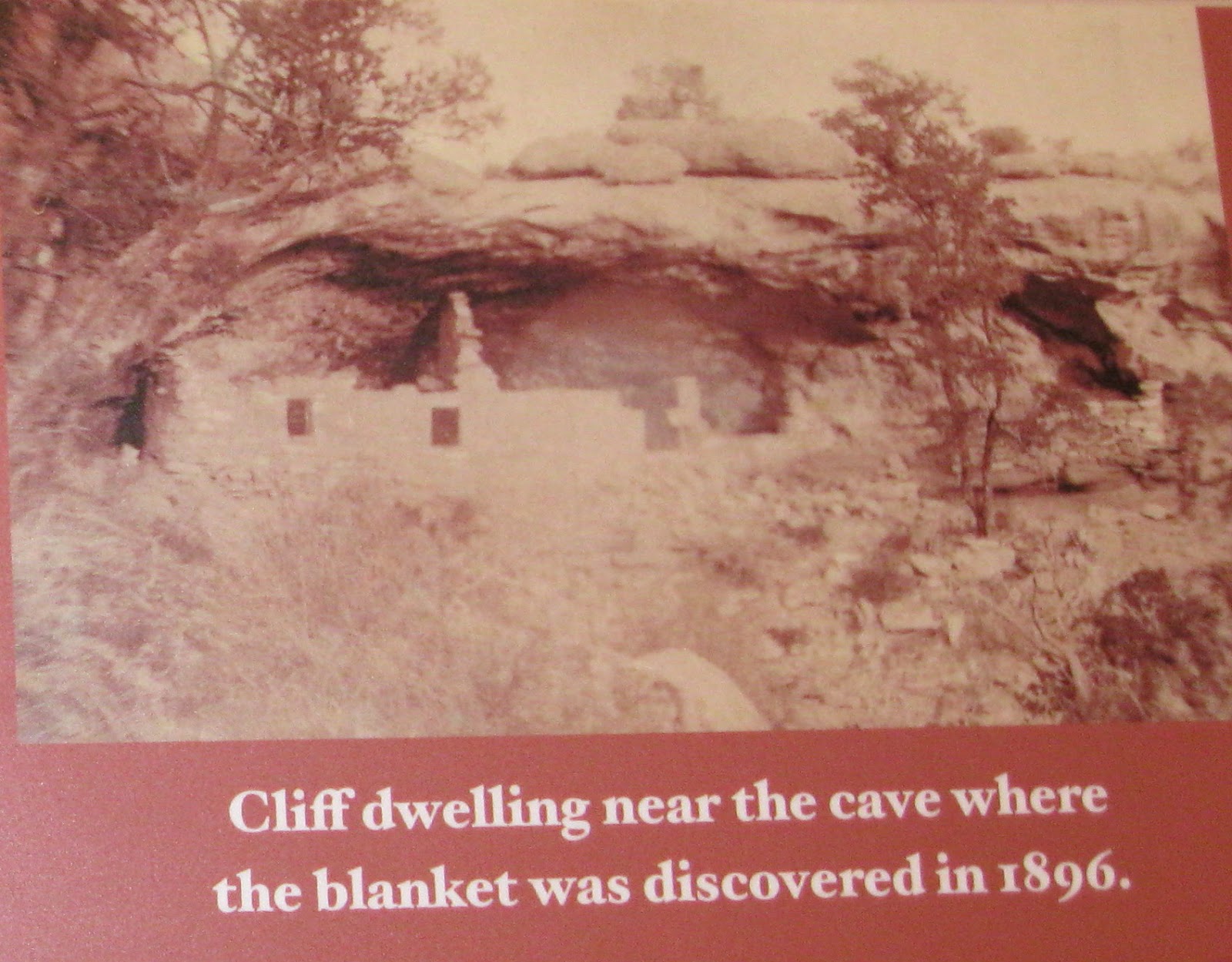
In 2004 the Sagstetters were looking at a 10 year old magazine that showed the photo of the cliff dwelling where the Telluride Blanket was found a century before. Bill was stunned to realize that he had visited this site; in fact it had been the first wild site that he had found in 1968. Equally stunning is that in the ten years since the photo was published, no one else had identified the site.
 
The Telluride Blanket is 57 inches by 59 inches and is described a “wearing blanket”, multiple uses, sleeping, wrapping for warmth, used to carry material, spread on the ground for sitting. The twill weave is difficult to master and this blanket must have been woven by an expert. The cotton must have come from a warmer climate than the area where the blanket was found.
 
The site visit to the ruin pictured found that the Telluride Blanket and the historic inscriptions was actually in an alcove 300 feet above the pictured site. The conditions above were dry and there was dirt where the pot containing the blanket could have been buried. The author mentions that what he thought was a very neat site in 1968, now tells an interesting story. We improve our powers of observation and understanding with experience.

There are ongoing investigations of the Telluride Blanket. Where did the cotton and dyes come from? What happened to the pot, beads, and awl that were originally found with the blanket? A question that hikers would ask is where is the site? If you were starting out as a canyon hiker in 1968, or even now, where would you look first?

The small room where the Telluride Blanket is on display doesn’t have any other Ancestral Pueblo artifacts. In the Telluride area the Utes are the people of interest and there are some displays relating to their activity in the mountain area. The San Juan Mountains were the center of their lives and the cycle of life is emphasized.