Wednesday, March 12, 2008

Butler Wash Ruins Overlook Trail

The Butler Wash Ruins Overlook Trail is a short 1.0 mile round trip to a large Ancestral Pueblo Ruins site in southeast Utah, west of Blanding, along the scenic byway Utah Route 95. This trail on the way to Natural Bridges National Monument has some of very spectacular scenery.

From the trail head the view west is to Comb Ridge, an 80 mile long sharp spined sandstone hogback that was a nearly impossible barrier to travel before the modern age. The east facing side is mostly the Navajo Sandstone layer.

The parking area here can also be used as a trail head for the Upper Butler Wash Trail that visits at least three ruins sites including the Ballroom Cave. Just inside the fence at the trail head an unnoticed and unmarked trail takes off to the right.

The main trail crosses through high desert of sparse Pinon Pine and Utah Juniper trees with a lot of bare exposed rock. This trail is a short introduction to canyon and desert hiking and the desert environment.

The trail ends at an overlook to the ruins, tucked under an alcove across a deep eroded canyon. At first glance it is one of those places where you wonder how did they get to that place.


Not visible from the overlook is a modest sized arch or natural bridge at the head of the canyon. Move to the left about 100 feet or walk across the slick rock to the right about 100 yards. The ruins here are thought to have been built and occupied about 750 years ago and abandoned by 1300.


There is a good trail guide with markers on this trail, commenting on the geological layers visible here and identifying a dozen or so of the local plants. Some of the shrubs noted are Cliffrose, Threeleaf Sumac, Mountain Mahogany and Utah Serviceberry.

It took me about 30 minutes to make the round trip to the overlook but there is a lot to explore here. Look for the old trail also. There is an opening in the fence near the turn in, for access to explore the canyon below the ruins.

Mule Canyon Roadside Ruins

The Mule Canyons Ruins Trail is a road side stop along Utah Route 95 on the way to Natural Bridges National Monument from Blanding, Utah. In the same area, there are also the Mule Canyon South Fork and North Fork Trails a short distance back to the east that are hikes rather than road side stops.


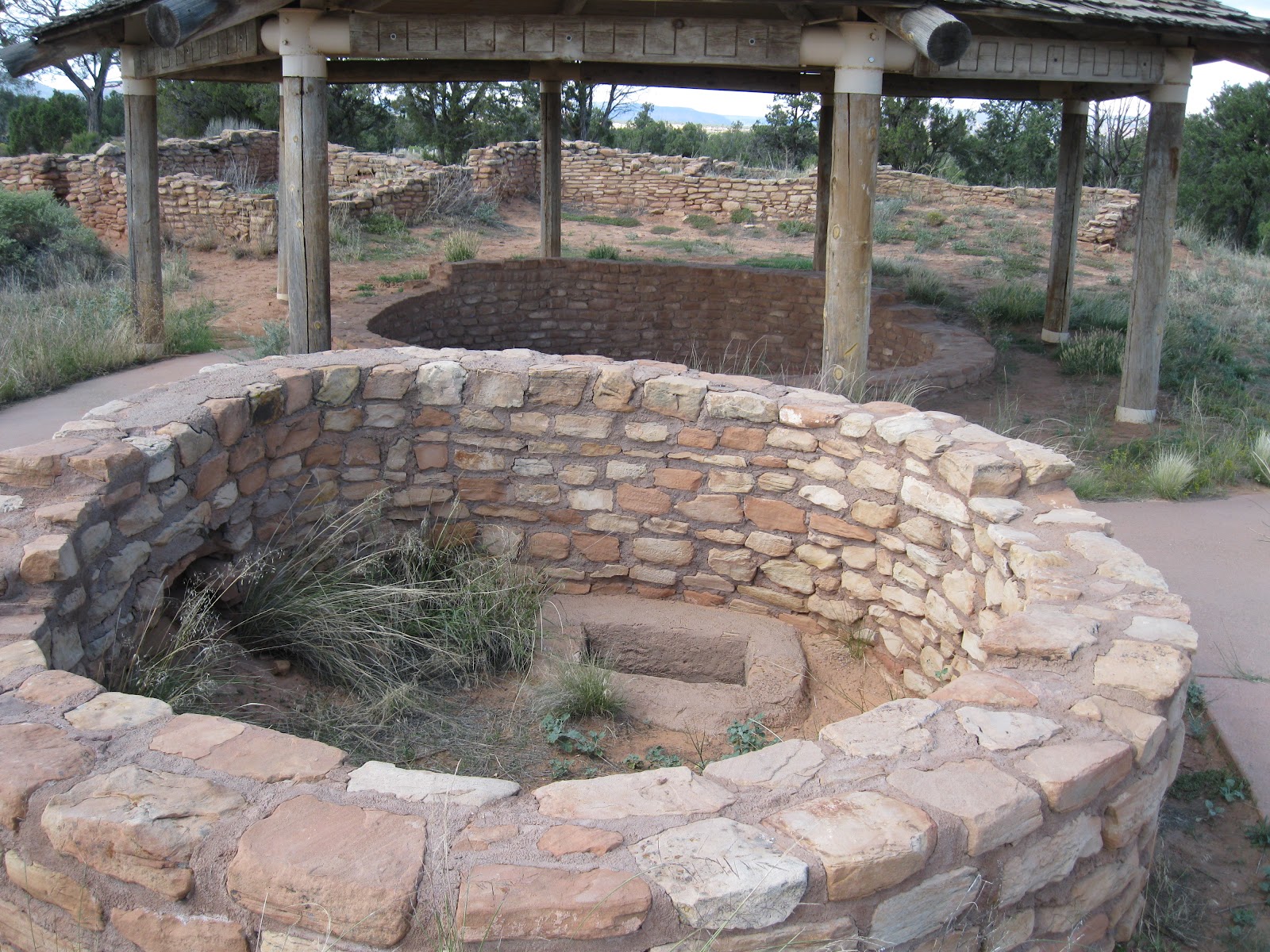
The paved trail is very short and features a well protected kiva. This circular kiva has the same features as the excellent ones visible at Mesa Verde. This appears to be one of the few mesa top pueblo sites in the Cedar Mesa area, at least that are easy to visit. There are many sites along trails in this area, but most seem to be associated with canyon rock alcoves.


There is also a tower with a tunnel connection to the kiva. We see similar tower and kiva connections at Mesa Verde. The Cedar Tree Tower and Kiva on Chapin Mesa and at Badger House on Wetherill Mesa there are similar connections.


The site at Mule Canyon has excellent views of the surrounding mountain ranges. The Blue Mountains near Monticello, Utah still snow covered in early March. Sleeping Ute Mountain is also easily visible to the east.


The pueblo structure has 12 rooms and there are supposedly crawl ways from the rooms to the kivas. The circular kivas are usually described as being for ceremonies, as present day Pueblo people use them that way. I  see these as having environmental uses also as earth contact living areas for shelter in cold weather.


The kivas are equipped with fire pits and ventilation shafts and the underground location would provide moderated temperatures and insulation. The underground tunnels would have provided access to stored food and materials without having to go outside.


There is not much hiking to do here, but the scene is quiet and the views spectacular. This site was developed as a rest area as part of the highway project. This site represents the Ancestral Pueblo culture at its height, when it was penetrating across southern Utah. Hardly anyone lives in this area now, yet 750 years ago the area was thriving.


528614_Cool Camo Russell Outdoors

Moki Dugway and Muley Point

Traveling south from Natural Bridges National Monument on Utah Route 261 the road drops steeply off of Cedar Mesa to the area along the San Juan River in southeast Utah.

The steep, narrow, twisty, gravel road that descends is called the Moki Dugway. It was constructed in 1958 by a mining company for transporting Uranium ore and drops 1100 feet in three miles.

If you're lucky, you won't meet anyone coming the other way. Just before the descent off Cedar Mesa down the Moki Dugway, there is a dirt road that runs several miles west to a view point called Muley Point.

The view here at Muley Point is to the south, overlooking the Goosenecks of the San Juan River with views to the spires of Monument Valley, on the Arizona-Utah border. It is just a short walk from the parking area to the edge, over a sandstone cap with a few scattered Pinon and Juniper trees. I felt a little nervous peering over the edge, a strong wind blowing on me.


There were wide cracks and large boulders that had tumbled off the rim. I felt like it would be my luck for one to break loose right when I was there and send me hurtling to the bottom.

The San Juan River is meandering here, flowing to the west, into Lake Powell behind the Glen Canyon Dam, where it joins the water of the Colorado River.


Goosenecks of the San Juan River

Along the rim of the Goosenecks of the San Juan River is a small State Park offering a spectacular view of the entrenched meanders, a thousand feet below the rim.

The San Juan River flows out of the San Juan Mountains in southwest Colorado and flows through the desert areas of the Four Corners area flowing west to meet with the waters of the Colorado River in Lake Powell.

Here the San Juan River has cut itself into a twisty course through layers of sandstone and shales of the Honaker Trail Formation and the limestone layers of the Paradox Formation. These are deeper layers of rock than are usually visible in the region.
There were some rafters visible way down there as I gazed over the edge. There is a one day raft trip from Bluff, Utah to Mexican Hat, but if you go past there, into the Goosenecks it is five days before you can get out.
 There is room in the park for some short hikes along the rim, gazing at the meanders from different angles. The terrain is treeless and probably has some desert wildflowers in season. There was a Navajo couple selling jewelry on the day I visited, a common sight in this region.


Valley of the Gods

At the south side base of Cedar Mesa in southeast Utah, as you finish the scary descent of the Moki Dugway, there is a graded gravel and dirt road winding 17 miles through an area of carved sandstone monuments called the Valley of the Gods.

The Valley of the Gods is a miniature of the nearby and more famous Monument Valley, and doesn't seem to get as much attention. No visitor center, gift shop, or bus loads of tourists.

I thought the road through here would make a good bike ride. It is reasonably smooth but has a lot of twists and turns and roller coaster ups and downs at the wash crossings.

Some of the formations have local names, like Castle Rock, Battleship Rock, and Rooster Butte. Some of the formations here are comparable to Monument Valley, but most are not as massive.

The terrain here is difficult desert. The clay in the soil prevents very much from growing. At the west end of the route is the Valley of the Gods Bed and Breakfast. It's probably very peaceful there.


(There is another post on a hike up the Lime Creek in the east part of  Valley of the Gods. Use the labels to find it.)
18407_$5 Shipping on Orders of $99 or More! 528614_Cool Camo Russell Outdoors