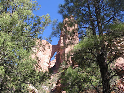
Arch Canyon in the Cedar Mesa area of southeast Utah is named for two large arches that are about eight miles up the canyon at the end of an ATV Trail. The trail head is up a BLM dirt road, 2.5 miles north of Utah Route 95, just west of the rugged Comb Ridge.
 At the end of the ATV trail the land status changes from the BLM to the Forest Service and the trail becomes a footpath. Cathedral Arch is visible at the trail head.
The forest at the upper end of Arch Canyon is dominated by Ponderosa Pines rather than the Pinon Pine and Utah Juniper forest of the lower canyon and patches of evergreen manzanita are common. The trail continues to cross and recross the creek that runs through Arch Canyon. In late October 2008, there was only a small amount of flowing water with pools forming in a few places.
 There didn't appear to be an angle to get blue sky through the Cathedral Arch from the trail. It was a long hike to get up this far and a long way back, so I didn't use up my energy to get up underneath for the blue sky angle.
 A few minutes more of hiking, Angel Arch comes into view. Besides the spectacular scenery and large arches, Arch Canyon has the cultural overlay of Ancestral Pueblo Ruins. There are many small sites in the canyon but they are hard to see much less get close to.
 At Angel Arch, it was possible to get an angle to see blue sky, but it involves maneuvering through some brush and finding a gap in the tall pines.

It looks like one could climb up higher and get under Angel Arch but it would take more energy than I had. It took me about 4:00 hours of hiking to get to this point and I turned around here.


 This is one of several trails in this BLM managed area that has a $2 per person day hiking permit fee. The trail head for the parallel Mule Canyon North Fork trail is another 0.5 miles along the same gravel road.


