The Valley of the Gods is a desert area of eroded sandstone buttes and pinnacles along the south edge of Cedar Mesa in southeast Utah. It is similar to the nearby and more famous Monument Valley, but provides a more natural experience.
Most visitors travel the 17 mile gravel scenic drive, stopping at the pullover view points to view the spectacular formations. There aren’t any marked hiking trails but the area is open for hiking and camping.
Rather than use the gate, I found a place to slide under the fence and hiked east toward the formation called Pyramid Peak. To the north are the cliffs of Cedar Mesa.
The vegetation is treeless with grasses, Snakeweed, Blackbrush, Mormon Tea, and Prickly Pear Cactus. Along the small washes there is some Rabbitbrush and Cliff Rose. At the east entrance to Valley of the Gods, there is a crossing of Lime Creek. The creek flows from the northeast and is a short distance to the east of Pyramid Peak.
The abandoned road passes to the south and east of Pyramid Peak and can be used as a trail, heading for a crossing of Lime Creek. There is enough water in Lime Creek to support Cottonwood trees along the banks. There is another fence with a gate to pass through before the creek corssing.
The abandoned road heads back southeast after the creek crossing. I stayed north following the many segments of cow trails that continue up the canyon, close to the creek banks toward the cliffs.
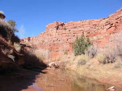
I thought the cliffs would be a dead end, but the creek makes a bend to the west and the environment changes from desert to a narrow moist canyon. I thought that with the water available here there might be some Ancestral Pueblo ruins sites along the south facing canyon face, but I didn’t see anything. I turned around after 2:10 hours of hiking at a pour off point that requires some scrambling to get past.
On the return hike I found a view where both the Valley of the Gods and the Monument Valley spires are visible. I hiked on a sunny mild 50 F degree early December day. In summer when most visitors arrive it can be too hot for much hiking, but this day was perfect. My total hike was 4:20 hours for about 8 miles.


 The Valley of the Gods is a miniature of the nearby and more famous Monument Valley, and doesn't seem to get as much attention. No visitor center, gift shop, or bus loads of tourists.


