The Cold Spring Cave Trail is one of the several short hikes on the east side of the massive Navajo sandstone Comb Ridge, west of the town of Bluff in southeast Utah. I started my hike 7.6 miles north of the south gate of Butler Wash Road, then a short distance down a bumpy side road.
This starting point is less than 0.5 miles north of the trail head area for the Monarch Cave Trail. None of these interesting trails are pointed out with signs.
I noticed that Bluff has new signs at the edge of town indicating the town was founded in 650 AD. The
Comb Ridge area was the home of some of the early settlers. From the trailhead area, the Cold Spring alcove is clearly visible, even some of the wall sections of the structures are visible. The trail leading across Butler Wash is easier to follow than most of the other trails and not much of the route crosses bare sandstone before reaching the canyon mouth area.
At the entrance to the canyon, there is a
rubble pile ruin perched on a high point on the opposite side of the canyon mouth. There isn’t an easy way to cross over and look closer, though it looks like it is feasible. The location of this site is interesting as it appears to be a lookout point. I haven’t noticed other ruins structures positioned like this in the Comb Ridge area.
The alcove is very long with small wall sections along the lower end and larger structures in the upper and deeper end. Besides the remaining structures, Cold Spring seems to have more interesting features than many of these sites. It took me about 0:30 minutes to arrive at the alcove.
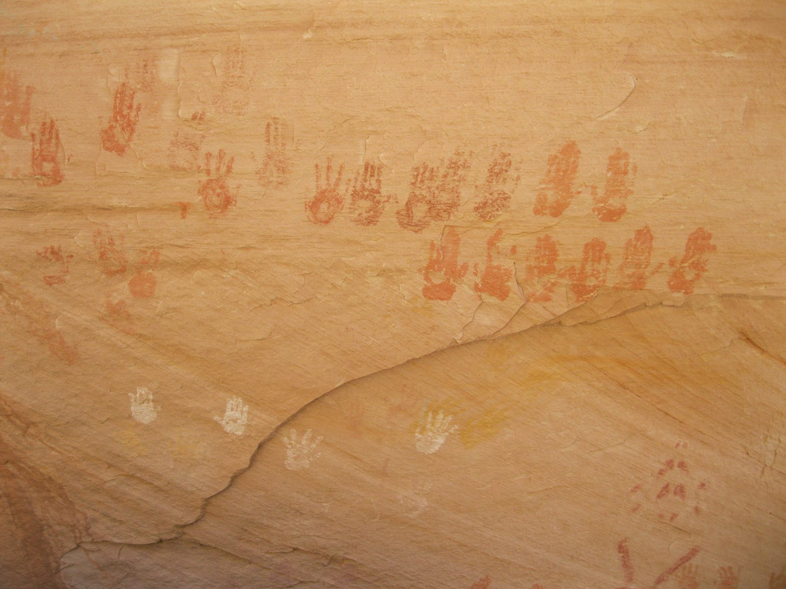
Cold Spring is particularly rich in
hand print pictographs. There are several panels spread all along the canyon walls and they use a larger variety of colors than is usually seen.
The other prominent feature here is the number of small grooves that appear to be for
grinding. These small side by side grooves are a different style than the larger grinding stones that are on display at the major sites at Mesa Verde and other interpreted sites. One of these several grinding stations has
petroglyph images built into the horizontal surface.
Near the entrance to the deep part of the cave there is a
circular kiva where some of the stonework looks to be well preserved with some of the plaster still in place. The water source for the site is in the deepest part of the cave. Water can be seen seeping from rocks and supports a growth of maidenhair ferns, and trickles down into a small basin.
Near the kiva on the right side of the deep part of the cave there is an
historic inscription from 1892. At Mesa Verde, Canyon de Chelly and other places on Cedar Mesa, some of the early explorers left inscriptions. This is the only one I know of in the Comb Ridge area.
I visited the Cold Spring Cave for about 1:00 hour. On the return hike I explored the area to the north, following cow trails across the drainages for about 1 mile and scanning the visible alcoves with binoculars. There is more to find in this area.
My total hike with this side trip was 3:30 hours. It was 43 F degrees when I started at 11:30 AM and 56 degrees at the 3:00 PM finish on a sunny late March day. I saw two other hiking groups during my hike, a total of seven visitors. The parking area for the nearby Monarch Cave Trail had several vehicles with tents pitched.